|
|
|||||||
|
Table of Contents |
A Late Iroquoian Village in Richmond Hill
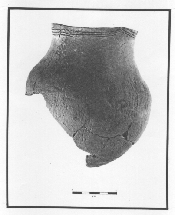
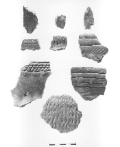
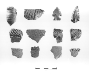
Richmond Hill's best documented Late Iroquoian village - known to twentieth-century archaeologists as the Boyle-Atkinson Site - was located southwest of the intersection of Yonge Street and Major Mackenzie Drive. It seems to have functioned as a major village for some fifty years, from about A.D. 1450 to 1500, and it provides a comprehensive picture of Late Iroquoian life in Richmond Hill.
Village work at Boyle-Atkinson likely reflected the traditional division of labour found among Iroquoian groups documented by Jesuit priests in the seventeenth century. Women planted, tended and harvested the corn, bean, squash, and sunflower crops. They worked the soil with small wooden spades, scraping it up to form hills some thirty or more centimetres (about twelve inches) high and a metre or two (three to six feet) across, in which they planted their seeds year after year. They also gathered the fruit of the elderberry, raspberry, spikenard, and goosefoot bushes which added flavour to an otherwise bland diet. Women were also responsible for the time-consuming tasks of cooking, sewing, and tending children. 10 The Iroquoian men worked at least as hard as the women, and their contribution to the village economy was no less important. They cleared the new fields that were always needed, since farming practices soon depleted the fertility of the soil. They gathered fish from nearby streams and caught birds to provide meat for their families' meals. They hunted bear and deer for food, for skins, and for personal prestige. The men also built the longhouses and constructed the palisades which protected the village from attack. They manufactured utensils and tools from wood, animal bones, and various varieties of stone. The men also participated in village government and carried out trade with other villages. 11 The extended family, living together in a single longhouse, constituted the basic unit of every aspect of Iroquoian life. Iroquoian society was matrilineal, in which descent was traced through the female line rather than the male line. Iroquoians were also matrilocal, with the extended family usually consisting of a woman and her daughters, or a group of sisters, living together with their husbands and children. Young girls played games that taught them how to perform household tasks and identify plants, and in a short time, they were pounding corn and helping their mothers in the fields. Boys were trained to hunt with bow and arrow, to trap, and to fish. They also played ball games and other sports, and learned about animal behaviour and habitats in order to develop the physical and mental skills they needed for survival. 12 Sporting events and feasts broke the regularity of daily tasks at what is now Boyle-Atkinson. Feasts incorporating games such as lacrosse, along with dancing and eating, were held to celebrate personal good fortune, to solemnize marriage or death, or to invest new leaders. 13 The clan segment appears to have been the basic unit of political organization among the Iroquoians. A clan segment consisted of all the members of matrilineal extended families who inhabited a single community and claimed their descent from a common female ancestor. Each clan segment probably had two headmen - a civil leader, who co-ordinated group activities within the extended family, and a war chief, who was concerned exclusively with military affairs. Collectively, the civil leaders of the various clan segments may have formed a village council. This council may have arranged public feasts, resolved differences between clan segments, and promoted trade with neighbouring villages. 14 Boyle-Atkinson is only one of several Richmond Hill Late Iroquoian villages dating from the years 1300 to about 1550 A.D. On the west side of town, from Elgin Mills Road north to beyond Gamble Road, archaeologists have located the McGaw,Murphy-Goulding, and Orion sites. And along Leslie Street in the eastern part of Richmond Hill, are the Reuben Heise and Watford sites. All these former villages are located in what geographers call the "South Slope" physiographic region of Richmond Hill - the middle of three east-west belts, between the exposed Peel Plain to the south and the less fertile Oak Ridges Moraine to the north. These sites are all found along headwater tributaries of the Don and Rouge rivers, and all are located on agriculturally promising clay or clay-loam soils. 15
Distances between the Late Iroquoian sites on the west side of Yonge Street suggest "a single community moving through time and space." Just 1.8 kilometres (about one mile) separate Murphy-Goulding and McGaw, while the distance from McGaw to Boyle-Atkinson measures 3.8 kilometres (over two miles). If the nearby Mill Street Site in Richmond Hill and the McNair Site in Vaughan also prove to be Late Iroquoian villages, then distances between the village sites become more uniform - between one and 1.8 kilometres. Assuming that relocation occurred every twelve to fifteen years due to soil exhaustion, these five successively occupied villages document over a century of Late Iroquoian occupation in Richmond Hill.17 The Iroquoian of this period appear to have prospered. Their households increased in number, longhouses grew in size, and villages expanded. 18 Yet Iroquoian occupation of the Richmond Hill area ended in approximately 1550 A.D. It seems that immediately before the arrival of Europeans, the Iroquoians living in south-central Ontario felt threatened by the increasing aggressiveness of the Five Nations Iroquois living in today's New York State. As a result, the southern Ontario Iroquoians abandoned their traditional homelands and their relatively exposed villages, and emigrated north into the region between Lake Simcoe and Georgian Bay to become part of the Huron Confederacy. 19 Notes11. Trigger,Children of Aataentsic,vol. 1,pp. 40-45, 100. 12. Ibid., vol. 1,pp. 45-48, 100-101. 14. Ibid., vol. 1,pp. 54-59, 102. 15. Archaeological Services Inc.,"Report on Phases 2 and 3,"p. 44.
Previous Next Copyright © Richmond Hill Public Library Board, 1991 |